Voluntary carbon markets are evolving under increasing scrutiny, as stakeholders seek greater confidence in the credibility of carbon offsets. Strengthening confidence in these markets can be supported by technological advancements in remote sensing for use in tracking project impacts. Emerging tools offer the potential to improve monitoring accuracy, therefore increasing buyer and investor confidence in project integrity, while at the same time lowering project costs. Decreasing costs can, in turn, make high-quality carbon credit verification more accessible to small-scale project developers.
Current Limitations in Data Collection
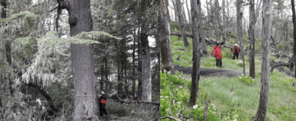
Conventionally, carbon stocks impacted by project activities or present in control areas would have been evaluated through field sampling: setting up plots and measuring variables specific to a project type (e.g., tree diameters and heights to calculate forest carbon content). These field methods can be costly and difficult to implement, particularly across large, roadless project areas. Remote sensing technology provides a scalable, cost-efficient alternative to conduct monitoring of carbon stocks across expansive and isolated areas. This technology can provide easily repeatable, systematic tracking of land-use changes and carbon stocks. Additionally, Synthetic Aperture Radar (SAR), Light Detection and Ranging (LiDAR), and optical imaging have shown promise as potentially useful remote sensing tools to improve measurement of key carbon-project variables as well.
Optical remote sensing data has been incorporated extensively into the determination of baseline deforestation and the monitoring of project versus proxy area deforestation in Reducing Emissions from Deforestation and Forest Degradation (REDD+) projects. Beyond this “traditional” use of remote sensing data to determine deforested areas, remote sensing tools have been incorporated into afforestation, reforestation, and revegetation (ARR) projects seeking to register with the Verified Carbon Standard under VM0047 as well. Namely, geospatial-determined stocking density data is used to determine a dynamic performance benchmark for an ARR project; that is, this data is used to calculate vegetative regrowth in a control area to determine additional regrowth/reforestation achieved through project activities. Still, there is room for significant growth in the use of remote sensing data in carbon projects. Several areas for potential growth are explored in the remainder of this article.
The use of remote sensing data to augment field-based estimates of forest carbon, known as model-assisted estimation or double sampling, is allowed under VM0047 and VM0048 and creates more precise and higher-integrity estimates of carbon stocks. EP Carbon believes this technique is underutilized, as it has been proven to be effective in reducing estimated uncertainty.
The Evolution of Aboveground Carbon Maps
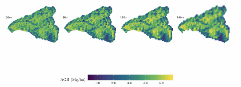
As remote sensing evolves and the nature-based-solutions landscape continues to grow, off-the-shelf maps of aboveground carbon (AGC) made by both commercial (for example, Chloris and Kanop) and academic groups can be leveraged to enhance the precision of carbon estimates and monitor forest-based carbon projects. EP Carbon is at the forefront of including these maps in carbon projects, utilizing AGC maps in the development and assessment of various projects that will be brought to market in the coming months and years.
Potential Uses of LiDAR
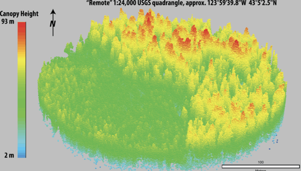
Although a proposed methodology to monitor biomass through LiDAR detection was rejected by Verra in 2024, a recent California-based study highlights LiDAR’s ability to provide highly-accurate, high-resolution biomass estimates: comparing LiDAR estimated biomass to field sampling, 94.7% of the measured biomass values from field plots fell within the 95% confidence interval of values predicted by a model derived from LiDAR data. Unlike optical sensors such as MODIS, Landsat, and Sentinel, which primarily detect reflected light from the canopy surface, active sensing technologies like SAR and LiDAR can penetrate vegetation layers, providing detailed three-dimensional structural data. This capability allows for significantly improved aboveground biomass estimates.
By pairing the use of LiDAR with field data collection, localized models can reduce error and uncertainty, offering more precise aboveground biomass assessments. While aerial LiDAR provides some of the most detailed forest structure data, its higher cost may be a barrier for certain project developers. In contrast, satellite LiDAR, such as data from NASA’s GEDI mission, offers a more accessible alternative, though with lower resolution and coverage limitations. Despite these cost differences, LiDAR demonstrates strong potential to improve carbon stock quantification, particularly in complex forested landscapes.
Multispectral Satellite Data
Multispectral satellite datasets, such as Sentinel-2 data, can be used to estimate aboveground biomass at different spatial and temporal scales as well. Using multiple time points significantly improves accuracy compared to single-time models by capturing seasonal changes in vegetation. This is particularly useful for REDD+ projects, where tracking biomass fluctuations over time is essential. These findings emphasize the importance of temporal data and careful feature selection in biomass estimation. The use of multispectral datasets can benefit smaller-scale carbon project developers by making biomass monitoring more accessible and cost-effective. By leveraging open-access or affordable multispectral satellite data, project developers can track forest biomass changes more efficiently and inexpensively.
Applications of Remote Sensing for Estimating Forest Carbon under Carbon Standards and Methodologies
As remote sensing tools, and methods for estimating forest carbon the carbon standards and methodologies have evolved to include the use of remote sensing tools in estimating forest carbon. The Equitable Earth standard’s M0001 Methodology estimates forest carbon and net GHG removals directly from remote sensing produced AGB maps, Equitable Earth is unique in this approach and does quantify uncertainty in their estimates, but uncertainty is not directly estimated from the forest in which removals occurring. Alternatively, Verra’s VM0047 methodology allows inclusion of remote sensing information through the use of double-sampling, in which a statistical relationship is built between remote sensing observations and field plots. Applying double-sampling allows for projects to reduce their needed field plots, or retain the same amount of field plots while achieving higher statistical certainty (Emick et al., 2023).
Limitations
Remote sensing techniques do not come without drawbacks. High-resolution satellite imagery, for example, does not always capture fine-scale disturbances, such as selective logging. Cloud cover and atmospheric interference can also negatively impact satellite imagery. Regardless of the remote sensing technique, incorporating ground truthing of data or verifying data from multiple sources is often necessary to further enhance the accuracy of carbon stock estimations. This validation process builds trust with potential buyers by ensuring that estimates are reliable and reflect the true carbon sequestration potential of a project. Still, ground truthing remote sensing data is often far less expensive and time consuming than collecting data exclusively through field measurements for an entire project or control area.
Moving Forward
Data and technology will continue to improve as new satellite missions are launched in the coming years, some of which have been specifically designed to improve the measurement of forest carbon stocks. Additionally, upcoming missions like NASA’s NISAR will produce high-resolution forest disturbance data, which will help to detect degradation and deforestation more accurately. As technologies continue to advance, they will further reduce monitoring costs. If carbon standards are open to allowing the controlled use of these innovative technologies to monitor carbon stocks, small-scale project developers will be able to use less expensive but reliable tools to verify carbon sequestration. A greater variety of projects may consequently gain access to carbon markets.

Ethan Emick, Technical Manager
Ethan’s work at EP Carbon comprises qualitatively and quantitatively assessing nature-based carbon projects to aid in VCS methodology selection and conformance with the VCS standard. Ethan works as a Technical Manager in geospatial and carbon accounting for a wide array of forestry projects. From his associated work at EP Carbon and academic studies, Ethan has advanced knowledge of inferential statistics, carbon accounting, geospatial and remote sensing analysis, and voluntary market carbon project design.